

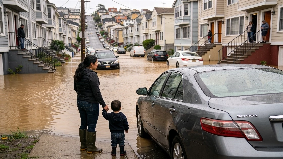
When high tides and storm runoff hit San Rafael's Canal District together, streets can vanish under water for hours or days. For residents like Anabel, who once got stuck behind a line of cars as floodwaters blocked Highway 101, the danger is real. She described in Spanish how she feared her car might stall in the rising water, with no way to turn around.
This winter, city officials warn that a historically strong El Niño could drive water levels even higher, especially during king tides. The Canal District, home to over 12,000 people and spanning about 2.2 square miles, sits mostly below sea level. Nearly one-fifth of San Rafael's residents live in this low-lying area, built on filled marshland that has been sinking for decades as sea levels climb. Many main roads are below sea level and can flood even on clear days, with water entering vehicles and first-floor apartments during high tides. The risk grows when storms arrive, as both high Bay tides and winter runoff from nearby hills can overwhelm drainage systems. Emergency manager Quinn Gardner told the city council that if both evacuation routes go under, responders may need boats to reach people stuck in their homes. In the worst scenario, some could be trapped for days without power or water. Gardner advised, "a five-gallon bucket and some trash bags could be the situation that you need to be able to shelter in place for a couple of days until the water is safe to leave." Gardner pointed out that San Rafael faces flooding risk from both high tides and winter storm runoff, which flows down from the hills into low-lying neighborhoods.
Flooding exposes economic and housing pressures
San Rafael's Canal District stands out from the rest of Marin County. More than 80% of its residents are Latino, and about half are low-income, according to the Canal Alliance. Many spend at least half their income on rent. Apartment buildings, auto shops, and grocery stores line the canal's edge, and the area is among the Bay Area's most densely populated. Even with warnings from the National Weather Service, such as the Coastal Flood Advisory issued for October 28 through October 31, 2026, some residents may not realize that flood alerts apply to their neighborhood too. The National Weather Service regularly issues these advisories when high tides threaten to flood roads and low-lying property before heavy rain arrives (National Weather Service San Rafael forecast).
Last year, Anabel was stranded for three hours in Corte Madera while trying to drive her children to sports practice. At home, water has reached her ankles in the street and seeped through her car door. Only sandbags kept it from entering her apartment. Another resident, Marina, faced a mudslide that nearly topped the fence outside her home. She now keeps inhalers ready for her children with asthma and tries to keep her car fueled in case evacuation is needed. But with high rents and rising utility bills, preparing for emergencies is a financial burden. "Trying to put money aside to be prepared, which we know is necessary, that's gonna be so hard," Marina said.
Evacuation plans and limited options
The city has declared a local state of emergency, allocating $500,000 in city funds and securing $3 million from the county for flood response. These resources will pay for more water pumps and community outreach, but Gardner called it "a billion dollar problem for San Rafael in the grand scheme of things." Even if only part of the Canal District's population needs to evacuate, Marin County does not have enough shelter space. The city can house about 3,000 people in Red Cross shelters, but many of those sites are also in flood-prone areas. Residents may have to seek shelter in other counties, far from their jobs and community networks.
Officials urge those in first-floor apartments to stay with neighbors on higher floors during high tides, but overcrowding and a lack of vacancies make this tough. Many families have nowhere else to go. Fear and distrust of government, especially with increased immigration enforcement, lead some to avoid seeking official help, according to Carly Finkle of the Canal Alliance.
Uncertainty ahead as El Niño approaches
How this winter plays out depends on the timing and strength of rainfall. Gardner explained that steady, moderate rain might let the city's drainage system keep up, but a heavy downpour during peak tides could overwhelm local infrastructure. The California Coastal Commission notes that king tide dates—such as November 24–26 and December 23–25, 2026, and January 21–22, 2027—are based on astronomical predictions and do not include storm surge or El Niño-related anomalies, so actual water levels can exceed forecasts when storms hit during high tides (California Coastal Commission King Tides Project). The commission also warns of flooding, landslides, and unsafe coastal water during these times.
The Canal District's vulnerability is made worse by its bowl-shaped topography, a result of historic land reclamation over marshland more than a century ago. As the filled ground keeps sinking and sea levels rise, water can pool and drain slowly after high tides or storms, affecting transportation, housing, and emergency access at once. Federal floodplain rules require that federally assisted housing and infrastructure projects in such areas account for higher future flood risk, using standards set by the Federal Flood Risk Management Standard and FEMA's 0.2-percent-annual-chance floodplain, or by adding two to three feet to the base flood elevation for critical actions (24 CFR Part 55).
If evacuation becomes necessary, Anabel plans to take her family north to Santa Rosa, but finding an affordable hotel for five people would be difficult. If her home were damaged, she would face the prospect of higher rent and a smaller apartment elsewhere. After more than 25 years in the Canal District, Anabel worries about the neighborhood's future as climate change raises sea levels. "If the Canal District sinks, it will be a great loss," she said in Spanish.