
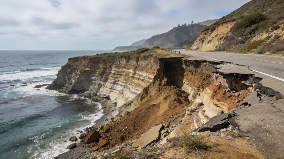
Researchers at the Lost Coast Headlands in Humboldt County have tracked a sharp retreat of the cliff top—22.3 meters, or about 73 feet, per year between 2016 and 2023. This pace of erosion, detailed in a new study from UC San Diego’s Scripps Institution of Oceanography, exposes the risks to California’s coastline and the infrastructure built along these cliffs. The study compared high-resolution airborne lidar data from 2016 and 2023 and found that retreat rates vary widely across the state. In certain hotspots, the amount of material lost matched roughly 800 dump-truck loads for every yard of shoreline. The Scripps team pinpointed major retreat zones at the Lost Coast Headlands and in the King Range, Redwood National Park, Point Reyes National Seashore, Big Sur, Martins Beach, Vandenberg Space Force Base, El Capitan State Beach, and Palos Verdes. Lidar technology let researchers separate cliff-top retreat from broader cliff-face changes, creating three-dimensional surface models now available to the public through the California Coastal Cliff Erosion Viewer. Danghan Xie, lead author and former postdoctoral scholar at Scripps, stated, "The cliffs are not stable. They erode and collapse over time." Scripps Institution of Oceanography reported that about 65% of California’s coastline consists of coastal cliffs or cliff-like terrain relevant to erosion monitoring.
Point Reyes National Seashore has experienced notable changes, with cliff tops receding by nearly 33 feet annually over the same period. The study identified Humboldt, San Francisco, San Mateo, and Monterey counties as having the highest rates of coastal cliff erosion in California. Other locations with retreat above 10 feet per year included Redwood National Park, the King Range, Big Sur, Martins Beach, Vandenberg Space Force Base, El Capitan State Beach, and Palos Verdes. The difference between extreme hotspots and the much lower statewide average—about 1.6 inches per year—shows why statewide averages can mask local infrastructure risk.
Major landslides and their impact
Large landslides have driven cliff loss, especially in Northern California. In 2023, a landslide at the Lost Coast Headlands displaced more than 1.4 million cubic yards of rock and soil, according to the Scripps Institution of Oceanography at UC San Diego. Adam Young, a coastal geomorphologist at Scripps and co-author of the study, explained that tall coastal slopes in places like Big Sur and the King Range can make such events more likely. The study’s main finding is that California’s coastal erosion is shaped by localized landslides and geological conditions, not by a single statewide rate. Tall slopes can release large volumes of rock and soil when destabilized, causing short-term retreat rates to far exceed long-term averages. Researchers stressed the need for a statewide lidar baseline, since isolated field observations cannot capture the scale and geographic variation of the issue.
The research team used lidar imagery from 2016 and 2023 to measure changes along the coast, setting up a monitoring framework that tracks both annual and seasonal change. The program now collects lidar data twice a year throughout California, updating erosion rates on both annual and seasonal levels. The public-facing Cliff Erosion Viewer turns this research into a location-specific tool for spotting retreat hotspots along the coast. The program’s funding currently runs through 2027, raising questions about long-term continuity if more support is not secured. As reported by FOX 5/KUSI, the findings give a factual basis for prioritizing repeat surveys and site-specific infrastructure assessments instead of applying a single erosion rate to the entire state.
Consequences for communities and infrastructure
Cliffs make up about 65% of California’s coastline, supporting key stretches of Highway 1, historic lighthouses, and popular viewpoints. The areas most exposed to infrastructure consequences include highways, railways, homes, public-access points, parkland, and other facilities near bluff edges. Repeated landslides in Northern California have forced closures of Highway 1, leading to expensive repairs and long detours for residents. Some incidents have been deadly: a 2019 landslide at Funston Beach killed a 22-year-old woman, and a contractor died in a Humboldt County slide last year. The erosion of cliffs threatens critical infrastructure such as highways, railways, homes, park lands, and public access points.
Large landslides have also occurred in Southern California, including in Palos Verdes during the study period. The research aims to improve hazard prediction and inform state planning, with annual and seasonal tracking of coastal erosion now underway. Southern California has more widespread use of coastal armoring, such as seawalls, which can slow erosion immediately landward of a structure but may speed up beach loss by disrupting natural sediment movement and wave processes. This tradeoff matters for regulatory decisions, as a seawall may reduce bluff retreat at a specific parcel while worsening public beach narrowing over time. The study’s infrastructure implications reach beyond residential property to highways, railways, parklands, lighthouses, and public-access facilities near unstable cliffs. Fatal cliff failures can happen without warning, even where a long-term average seems modest.
Coastal erosion is already affecting California transportation infrastructure, including emergency protection and repair work on Highway 1. In 2026, a crack formed beneath Coast Highway near Crystal Cove between Newport Beach and Laguna Beach, prompting Caltrans to place four-foot-tall sand-filled barriers beneath the roadway as interim protection while a fill buttress reinforced with large rocks was planned at the slope base. Caltrans linked the intervention to wave-energy exposure and extra vulnerability created by changing coastal conditions and tidal events, as reported by the Los Angeles Times. Emergency stabilization can keep a road open for a time but does not remove the underlying erosion hazard.
The study’s findings are part of a broader coastal-hazard monitoring system that uses lidar, satellite imagery, photogrammetry, and unmanned aerial systems to track shoreline and landslide change. These methods let agencies measure both the horizontal position of the shoreline and the three-dimensional volume of failed material, supporting hazard mapping, infrastructure planning, and post-landslide assessments. The ongoing monitoring and public-information effort is designed to identify changes that may not show up in older statewide datasets, providing critical data for California’s future coastal management.
For more on the science and policy implications, see the official Scripps Institution of Oceanography release and previous Chronicle coverage.